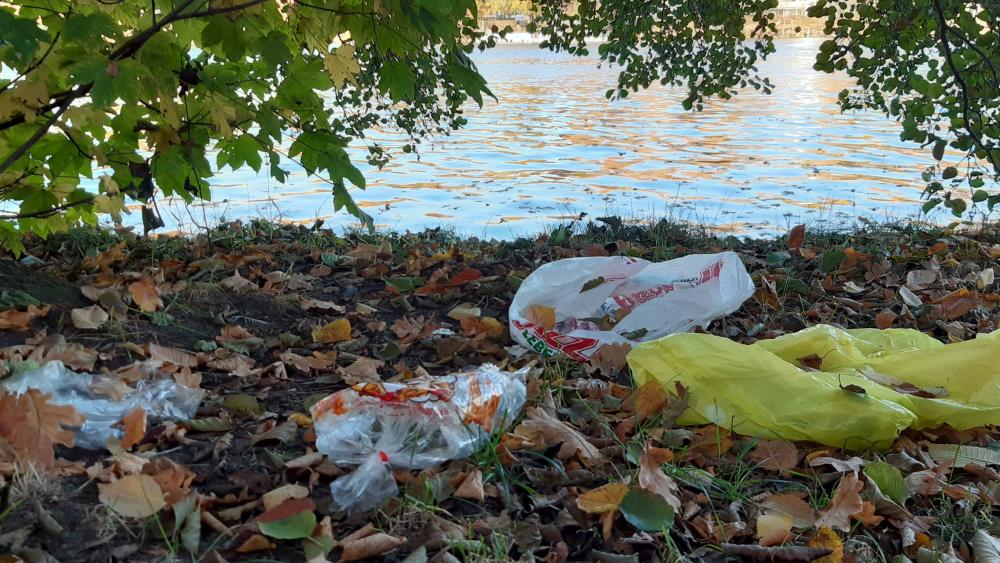
Plastic litter at the riverbanks of Berlin's River Spree. | Photo: Martin Blettler
From November to December 2021, the IGB research team took samples from the water and riverbanks at 27 bridges over the Spree, Havel, Teltow and Landwehr canals. The scientists examined the proportion of plastic in the waste found, its distribution in different sections of the river, and the main components of the plastic waste, covering a total area of 20,250 square metres.
Rubbish in and around the Spree: 96 percent plastic, 35 percent of which is food packaging
'We were astonished that plastic accounts for such a high proportion of water pollution caused by rubbish. Only around four percent of the waste we examined was glass, paper, aluminium or other metals”, said IGB researcher Dr Oleksandra Shumilova, author the study. The results also show that 35 per cent of plastic waste is food packaging, followed by cigarette filters, which also contain plastic. The most commonly found polymer was polypropylene, accounting for 41 percent.
On average, the researchers discovered approximately two large pieces of plastic per ten square metres (0.17 per square metre). 'We would certainly have found more plastic in the summer than in November and December. In addition, people's mobility was still severely restricted in 2021 due to the pandemic. Against this backdrop, it is interesting to note that surprisingly few masks were found", explained lead author Dr Martin C. M. Blettler. Martin Blettler has conducted the study while being a Humboldt Research Fellow at the Ecohydraulic group at IGB led by Dr Alexander Sukhodolov, and presently works at the Argentinian Institute for Research and Development in Bioengineering and Bioinformatics IBB in Oro Verde.
In a European comparison, the waste density of the sample campaign was at the lower end of the scale. On the banks of the Adour River in southwestern France, a 2018 study found an average of 14 pieces of plastic waste per square metre, whereas a 2025 study of urban riparian areas of central Italian rivers found peak values of 28 pieces per square metre.
The five most polluted locations in Berlin were: The Moabiter Bridge had the highest concentration of plastic waste, followed by the Mörschbrücke (Westhafen Canal), the Weidendammer Bridge (Spree), the Hiroshimasteg (Landwehr Canal) and the Juliusturmbrücke (Havel). The Oberbaum Bridge ranked tenth among the most polluted sites.
In the urban Spree, waste only goes in one direction: into the river and not back out again
Another key finding of the study concerns the dynamics of macroplastics on the banks of the Spree, especially in urban areas with artificial bank reinforcements. These concrete or stone structures make it difficult for waste to return to the shore, resulting in an accumulation of plastic waste in the river. Along the urban section of the Spree in Berlin, the banks mainly consist of artificial embankments between one and three metres high, restricting the connection between the riverbed and the land.
The research team has shown that the litter in these sections of the Spree with sheet pile walls only moves in one direction: from the riverbank into the river. Most plastic waste is either blown in from the bank by the wind or washed in during rain. Due to the high sheet pile walls, it cannot then get out again. In natural river courses, the water washes it back to the bank. From an ecological point of view, this is not necessarily better than if it remains in the water. But at least it can be collected more easily there”, explained Alexander Sukhodolov, who co-led the study.
The authors therefore recommend cleaning the riverbanks. Studies such as this one help us to better understand the origins and spatial distribution of plastic, enabling us to make informed decisions about which sections of the river should be prioritised for cleaning and monitoring.
******
Approach and sampling:
Twenty-seven bridges over the Spree and Havel rivers, as well as the Teltow Canal, the Landwehr Canal, and Westhafen, were selected as sampling stations for the field campaign. This covered the most important waterways. Sampling was carried out in November and December 2021. Three 50 m long and 5 m wide sampling transects were selected near each bridge within the three river sections: riverbank, water/land interface, and the river or canal. The total sampling area was 20,250 square meters. In addition, the bank structures were classified as: with abundant and tall vegetation; little vegetation and mainly grass; and artificial banks without plants. In the laboratory, the plastic items were counted and classified according to the guidelines proposed by the United Nations Environment Programme/Intergovernmental Oceanographic Commission (UNEP/IOC), as described in the “Guidelines for the Collection and Monitoring of Marine Litter.”